Kandersteg in 2 days: from Griesalp to the Blüemlisalphütte and the Oeschinensee
You climb through the Griesalp valley, sleep at 2,840 m in a Swiss Alpine Club hut, watch the sunrise over the Alps and descend to the blue Oeschinensee, with an optional swim. This is what you need to know.
By Santiago, Clas Tours · Updated October 2026
What this crossing is
It is one of the most complete mountain tours in the Bernese Oberland: you cross from the Kiental valley to Kandersteg via the Hohtürli pass (2,778 m) and sleep at the Blüemlisalphütte (2,840 m), at the foot of the Blüemlisalp massif. The next day you descend to the Oeschinensee, one of the most photographed lakes in Switzerland, and from there to Kandersteg.
Done over two days it's a different experience from doing it in one go: you reach the hut with time to spare, have dinner with a view and watch the sunset and sunrise in the high mountains.
Total distance
~16 km
Ascent (day 1)
+1,450 m
Descent (day 2)
~1,680 m
Highest point
2,840 m
Difficulty
T3
Data from Bergwelten (Griesalp – Hohtürli – Kandersteg: 16.1 km, 7 h 45 min in total, T3). The SAC rates the ascent from Griesalp to the hut as T2 (4 h, 1,450 m); BLS and Bergwelten rate it T3. Sources at the bottom of the page.
A bit of history
The Blüemlisalp massif
The name means something like "alp of the little flowers". The Blüemlisalp is a glaciated massif with peaks over 3,600 m: the Blüemlisalphorn (3,660 m) is the highest, next to the Wyssi Frau (3,648 m) and the Morgenhorn (3,620 m). Folk tradition tells that there was once a very rich alp whose inhabitants, out of pride, were buried under the ice. It is a legend, but it helps to imagine why this wall of ice above green meadows is so impressive.
The Blüemlisalphorn was first climbed on 27 August 1860: Leslie Stephen, R. Liveing and J. K. Stone, with guides Melchior Anderegg and Pierre Simond. They left the Oeschinen chalets at 2am and reached the summit around 8. That is why the massif is known as one of the cradles of mountaineering.
The hut
The Blüemlisalphütte belongs to the Blüemlisalp section of the Swiss Alpine Club (SAC), at 2,840 m, very close to the Hohtürli. It is the starting point for many ascents in the area, and a few minutes away there is a climbing area. It has more than a hundred places and is part of the multi-day route called the Bärentrek.
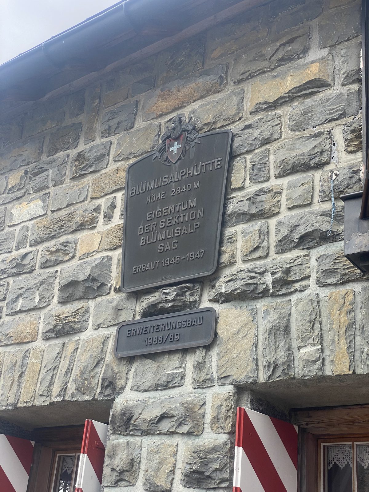
The plaque on the façade says it: the building was built in 1946–1947 and extended in 1988/89. In summer 2023 there was construction work, and the hut stayed open to guests.
The hut's plaque: 2,840 m, built 1946–1947
The lake
The Oeschinensee lies at 1,578 m, covers a little over 1 km² and is about 56 m deep. It was formed by ancient rockslides that dammed the valley. In the 17th and 18th centuries sulphur was mined on the Oeschinenalp, and since 2007 the lake has been part of the UNESCO World Heritage Site Swiss Alps Jungfrau-Aletsch.
Getting to Griesalp
By public transport
Train to Reichenbach im Kandertal (hourly RegioExpress from Bern or Brig) and from there PostBus 220 to Griesalp. BLS describes it as the steepest bus route in Europe: very tight hairpin bends, so take it calmly. In 2026 it ran from 23 May to 18 October. Confirm the timetables each season at BLS and SBB.
By car
There are pay car parks at Tschingelsee and at Griesalp. Keep in mind that you finish in Kandersteg, not where you left the car, so plan your return: the most practical way is to arrive by public transport.
Returning from Kandersteg
The finish is in Kandersteg, which has a train station. From the gondola valley station there is a bus to the station. If you are going down by the Oeschinensee gondola, in 2026 it ran from 8:30 to 18:00 (until 20 September) and until 17:00 (21 September to 8 November); the downhill ticket cost CHF 26.20 for adults and CHF 14.10 with a Half Fare card or for children. Check times and prices before you go.
Ascent of about 4 to 4 h 30 of actual walking, with +1,450 m of elevation gain. With breaks, allow 5 to 6 hours.
Griesalp (1,408 m). You set off on a marked path through forest and meadows.
Underi and Oberi Bundalp (1,840 m). Grazing alps, the last gentle stretch before the steep climb.
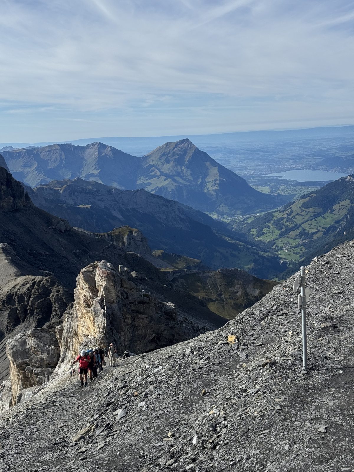
The Hohtürli climb. A steep rocky path with chain-secured sections leads up to Uf der Wart (2,508 m).
Rocky valley to the Hohtürli (2,778 m). Stone landscape, close to the Blüemlisalp glacier. Here you enter the pass linking Kiental with Kandersteg.
The Blüemlisalphütte (2,840 m). A few minutes above the pass. You arrive, settle in, and there is time to rest, have dinner and watch the sunset.
Sunset at the hutSunrise from the hut
Sleeping at the hut
You sleep in shared dormitories (bunks). The hut provides blankets, but you must bring a sleeping-bag liner.
Dinner and breakfast (half board) are included. The cooking is homemade, with wines mostly from the Valais. There is a vegetarian menu if requested in advance.
Card and cash are accepted for drinks.
The staffed season runs from mid-June to mid or late October, and is in full operation from July to September.
Day 2: from the hut to the Oeschinensee and Kandersteg
Descent of about 1,680 m. Allow about 3 to 4 h of walking to Kandersteg, without breaks and without a swim (7 h 45 min total route minus the first day's ascent).
Breakfast and departure. You set off early to have more time at the lake. The descent heads west.
Oberbärgli (1,978 m). Then comes a steep descent to Underbärgli, so it's wise to take it calmly and with poles.
Underbärgli (1,800 m). There are restaurants, a good spot for a break.
Oeschinensee (1,578 m). Long stop: photos, lunch and, if the weather allows, a swim.
To Kandersteg. On foot along the Oeschibach stream, or by gondola for the last ~400 m of descent.
The Oeschinensee and the Blüemlisalp wallsThe lake with snow in autumnThe valley during the descent
Yes, you can: swimming is allowed, at each person's own risk. There are no changing rooms, showers or lifeguards. The shallow south and west shores are the most used for cooling off.
The water is cold. It's a mountain lake at 1,578 m. One reference reading showed about 11 °C; in high summer it can rise, but expect cold.
Go in slowly, don't jump in all at once, and stay close to the shore.
After a long descent and with a warm body, a short dip is the most sensible thing. Dry off and warm up quickly.
Bring swimwear and a small towel; they take up little space.
Safety and conditions
It is not an easy hike. It has a long, steep ascent, a chain-secured section towards the Hohtürli and a steep descent. It requires good fitness, mountain footwear and no fear of heights.
Snow early in the season. In June and sometimes in October there may be snowfields on the Hohtürli. Check the state of the path with the hut or with Kandersteg before setting out.
Rockfall at the Oeschinensee. Because of the risk of rockfalls (partly linked to thawing permafrost) there were trail and shore closures in 2020, 2021 and July 2025. Check the official notices before you go.
Summer thunderstorms. They are common in the afternoon. That's why you set off early.
Cold and altitude. At 2,840 m it is cold even in summer, especially at night and at dawn.
Weather. Check the forecast at MeteoSwiss and the hut's bulletin.
Best time to go
July to September: the hut is in full operation and the path is usually free of snow. It's the safest and busiest time.
June and October: the hut is open only part of the time and there may be snow or ice. Better to check before organising.
Rest of the year: it is not a hiking route; the winter room is for emergencies only.
What to bring
Mountain boots with a good sole, already broken in (mandatory).
Layered clothing, waterproof jacket, hat and gloves for the night and dawn.
Sleeping-bag liner, headlamp, earplugs (shared dormitory) and minimal toiletries.
Water for the climb and something to eat along the way. With Clas Tours, dinner, breakfast and 1 litre of hiking tea are included.
Poles (highly recommended for the descent), sunscreen, sunglasses.
Swimwear and a small towel if you want to swim.
Card or cash for drinks, and valid personal insurance.
FAQ
How long does the Griesalp – Blüemlisalphütte – Kandersteg crossing take?
It takes two days. The first climbs from Griesalp to the hut (about 4 to 4 h 30 of walking, +1,450 m). The second descends past the Oeschinensee to Kandersteg (about 3 to 4 h of walking, not counting breaks and the swim).
How difficult is it?
It is a demanding mountain route, T3 on the SAC scale according to BLS and Bergwelten. It has a steep section with chains towards the Hohtürli and a steep descent. Good fitness and no fear of heights are required.
Can it be done in a single day?
Yes, some people do it in one go: about 16 km and close to 7 h 45 of walking according to Bergwelten, with +1,450 m of ascent. Sleeping at the hut lets you do it calmly and see the sunset and sunrise in the mountains.
When is the hut open?
The Blüemlisalphütte is staffed from mid-June to mid or late October, and in full operation from July to September. Outside those dates only the emergency room is open. Always book in advance.
Can you swim in the Oeschinensee?
Yes, swimming is allowed, at your own risk. There are no changing rooms, showers or lifeguards. The water is cold, like a mountain lake, so go in slowly and only for a short time.
How do I get back to Kandersteg from the lake?
You can continue on foot along the Oeschibach stream to Kandersteg, or take the gondola from the lake for the last 400 m of descent. The gondola has seasonal timetables, so confirm them.
What do I need to bring to the hut?
A sleeping-bag liner (mandatory: the hut provides blankets but not sheets), card or cash for drinks, warm clothes, a headlamp and mountain footwear. Dinner and breakfast are included if you go with Clas Tours.
Timetables, prices and path conditions change each season; check them before you go.
Prefer to go with a guide, in Spanish?
I run this tour with small groups: planning, pre-trip guidance and all the information in your language, so all you have to do is enjoy it.
Kandersteg with Clas Tours
CHF 320
per person · all inclusive (guide, night in the hut, dinner and breakfast) · minimum 2 people Groups of 7 or more: CHF 260 per person · maximum 10 people